


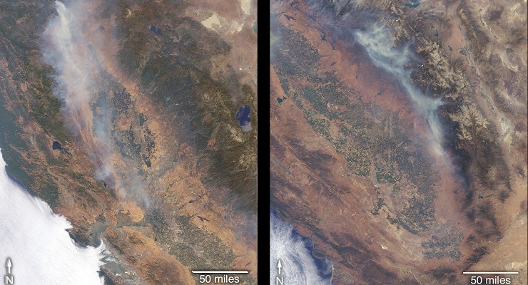


More than a dozen wildfires are burning in the state of California, with several of them threatening life and property. The Ferguson Fire ignited July 13 in the Sierra National Forest west of Yosemite National Park. Much of the forest in this area suffered extreme stress due to the extended drought of 2012 through 2017, and bark beetle damage, leaving many dead trees through which the fire has burned rapidly. Many surrounding towns have been under evacuation orders, and many popular areas of the national park were closed on July 25.
On July 23, another fire ignited northwest of Whiskeytown Lake, a reservoir in northern California. Dubbed the Carr Fire, it remained relatively small through July 25, but advanced rapidly toward the city of Redding the following day, prompting mass evacuations.
The Multi-angle Imaging SpectroRadiometer (MISR) instrument on NASA’s Terra satellite passed over California on July 27 and July 29, observing the Carr Fire on July 27 and the Ferguson Fire on July 29. The MISR instrument has nine cameras that view Earth at different angles.
MISR was built and is managed by NASA’s Jet Propulsion Laboratory in Pasadena for NASA’s Science Mission Directorate in Washington.
It collected images from MISR’s nadir (downward-pointing) camera on each day. The angular information from MISR’s images is used to calculate the height of the smoke plume, results of which are superimposed on the right-hand side of each figure. The results show that smoke from both fires remained relatively close to the ground, leading to a greater impact on local air quality on these days. The San Joaquin Valley Air Pollution Control District issued an air quality alert July 25 for the entire California Central Valley. A pair of stereo anaglyphs provides a three-dimensional view of the plume. Red-blue glasses with the red lens placed over your left eye are required to observe the 3D effect.
These data were acquired during Terra orbit 98973 and 99002. The smoke plume height calculation was performed using the MISR INteractive eXplorer (MINX) software tool, which is publicly available at https://github.com/nasa/MINX
The MISR Plume Height Project maintains a database of global smoke plume heights, accessible at:
https://www-misr.jpl.nasa.gov/getData/accessData/MisrMinxPlumes2/
 Get our daily Pasadena newspaper in your email box. Free.
Get all the latest Pasadena news, more than 10 fresh stories daily, 7 days a week at 7 a.m.