


[Updated] Buses on the planned North Hollywood to Pasadena Transit Corridor could likely make their way directly into Pasadena off the SR-134 Ventura Freeway at Fair Oaks Avenue and then follow an east-west round trip route along Colorado Boulevard, based on an informal consensus at a Metro workshop at Pasadena City College Wednesday.
Local residents also said they want safe, shaded stations, with attention to bike parking.
Metro held two meetings at PCC Wednesday to gauge public input regarding the routing of the bus rapid transit (BRT) service through Pasadena.
The 18-mile Transit Corridor is a key regional connection between the San Fernando and San Gabriel Valleys, and would feature connections to the Metro Red, Orange and Gold Lines as well as Metrolink and other municipal bus lines.
It is currently in the environmental review process, following a 60-day public scoping process which ran from June 17, 2019, through August 15, 2019.
The $267 million project is anticipated to open in 2024. It will run through North Hollywood, Burbank, Glendale, Eagle Rock, and Pasadena.
According to a Metro presentation and handout, the high-efficiency electric bus rapid transit service will provide “more reliable and convenient travel” by featuring enhanced stations with passenger amenities like real-time arrival/departure information; some dedicated bus lanes — none are contemplated for Pasadena, however; off-board fare collection and/or all-door boarding; more frequent service with limited stops; and transit signal priority, giving buses more green light time through intersections.
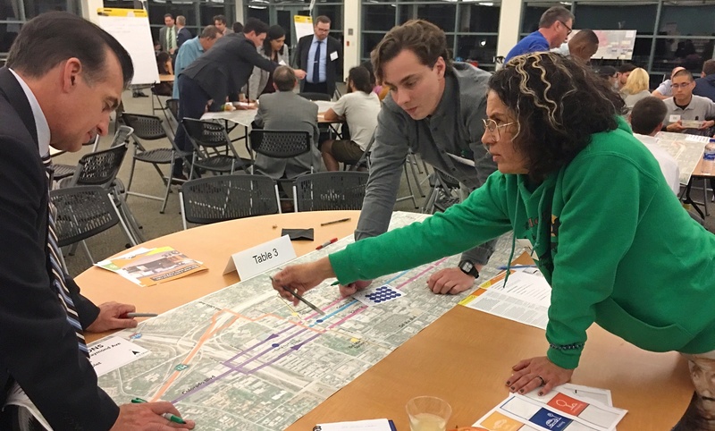
Representatives from Metro, Here LA, and Kimley-Horn led dozens of participants in a series of interactive exercises to gauge interest in the line itself, and then rate what amenities they would see as important.
Moderator Stephen Sanford called the evening “data collection.”

Workshop participants were first asked to describe their familiarity with Metro and their own public transportation usage with small hand-held live polling devices, which fed immediate data to Metro for use in their eventual station and routing decisions, as well as their Environmental Impact Reports, which should be in draft form by spring 2020.
Next, participants created “Priority Pyramids,” where subjects such as parking, service and amenities, landscaping, bike lanes, sustainability, and pedestrian experiences were ranked by each participants in a pyramid shape using colored stickers for each subject.
Participants then voted for station amenities by dropping colored balls into clear plastic bins for such items as shading/weather protection, public art, real time bus arrival/departure phone apps and bike parking.
Finally, participants examined large-format maps detailing proposed BRT routes through Pasadena, choosing from a number of options:
- BRT buses exiting the 134 Freeway at Fair Oaks and connecting at the Memorial Park Gold Line station, then continuing east on Colorado Boulevard.
- Buses exiting the 134 at Orange Grove and moving through Old Pasadena and continuing east on Colorado Boulevard to Hill Street.
- Buses operating in mixed-flow lanes one way east along Green Street to Hill Avenue. Buses would then return west on Union Street.
Participants at most tables during the Wednesday evening meeting selected the Colorado Boulevard route, although one workgroup favored a loop which would travel east on Green Street and then return west along Colorado Boulevard, instead of the Green Street/Union Street loop.
Another group also proposed staggered bus stations along the route, as opposed to stations which run parallel along Colorado, Green and Union Streets.
Madison Heights resident Erika Foy said she was concerned that a route that favored the Green Street/Union Street loop might create “upsizing” in those residential areas. In such a case, posited Foy, developers might create larger projects, using the arguments that any housing built along the route would be necessarily larger due to their proximity to transit lines.
Foy feared that such a scenario would create denser residential neighborhoods along the route.
 Get our daily Pasadena newspaper in your email box. Free.
Get all the latest Pasadena news, more than 10 fresh stories daily, 7 days a week at 7 a.m.