


 2 comments

Pasadena Fire Chief Chad Augustin faces the City Council on Monday, Jan. 23, to present details of Pasadena’s new Citywide Evacuation Plan, which he earlier presented before the Public Safety Committee.
“We expect in the next week, the city will move forward with the emergency manager position and under that person’s leadership, one of the top priorities would be to start exercising this plan,” Augustin said during the Public Safety Committee meeting Wednesday.
The evacuation plan will provide a framework to expedite the movement of people and animals from a hazardous area during disasters. The plan also provides templates for emergency communications that address assembly points, evacuation points and reunification centers.
The department originally came up with an evacuation plan for wildfire scenarios, but eventually expanded it to address other disasters. The Evacuation Plan now identifies three hazards as “high risk” for Pasadena: wildfires (especially the wildfire urban interface), floods (including wind-driven water), and hazardous materials release.
The Fire Department also cites climate change as a factor that may increase both the likelihood and consequences of wildfires and floods.
In the report submitted to the Public Safety Committee, the Fire Department said the plan lists down actions to be taken by residents and relevant departments in the event of disasters.
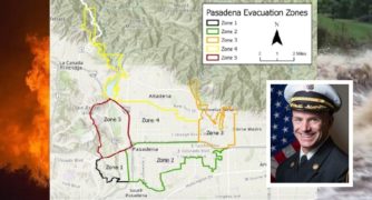
The plan divides the city into five zones based on evacuation risk and provides an evacuation map that will guide residents to the most appropriate assembly point, a shelter plan for the displaced and a reunification plan for families that may be separated by evacuation, among other things.
Zone 1 encompasses the South Arroyo area with a black boundary (see picture above); Zone 2 includes downtown Pasadena and parts of the city below the 210 with a green boundary. Zone 3 includes the Hastings Ranch area and parts of Eastern Pasadena with an orange boundary.
Zone 4 encompasses parts of the city that are above the 210 freeway and includes where the city boundaries head north with a gold boundary. Zone 5 contains the North Arroyo area including the Rose Bowl with a red boundary.
The main evacuation routes will be the 210 freeway and the 110 freeway. Avenues and boulevards will be used to alleviate traffic in case of emergencies.
The Fire Department said the Pasadena Evacuation Plan, which consists of over 80 pages including appendices, does not replace the need for existing Emergency Operations Center procedures and associated Emergency Operation Plans.
Fire Chief Augustin’s report will be for the City Council’s information only. No action is expected at this time.
 Get our daily Pasadena newspaper in your email box. Free.
Get all the latest Pasadena news, more than 10 fresh stories daily, 7 days a week at 7 a.m.