


 0 comments
Engineers at NASA’s Jet Propulsion Laboratory in Pasadena are providing an instrument that will allow a nonprofit-run satellite to spot “super emitters” of greenhouse gases, such as carbon dioxide and methane, from space, according to JPL.
The satellite, being built by the organization Carbon Mapper and targeted for launch in 2023, will carry a cutting-edge imaging spectrometer, JPL announced Thursday in a written statement. It will use the high-tech tool to detect significant concentrations of heat-trapping greenhouse gases in the atmosphere.
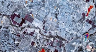
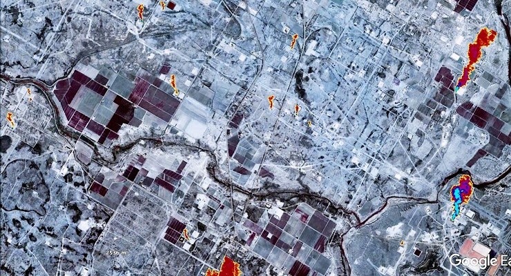
“Where a digital photograph breaks down visible light into just three colors — red, green, and blue — an imaging spectrometer breaks down light into hundreds of colors to reveal the unique spectral signatures of molecules such as methane and carbon dioxide in the air,” the statement said. “ The data collected by the instrument will help to find super-emitters: The small percentage of individual sources that are responsible for a significant fraction of global emissions of methane and carbon dioxide.”
JPL Earth Science and Technology Directorate Director James Graf said the project is groundbreaking in more than one respect.
“JPL is excited to be pioneering this research effort, which will provide critical information about greenhouse gases and the future of Earth’s climate,” Graf said. “This effort is the first time we have partnered on a space mission with a consortium of nonprofit organizations, universities, and the State of California.”
The scientists at JPL have a lot of experience when it comes to imaging spectrometers, which it has been using on spacecraft and other scientific instruments since the 1980s, according to JPL.
The Carbon Mapper satellite will boast resolution of about 30 meters per pixel, allowing it to spot sources of pollution such as cracked gas lines and oil leaks, JPL Scientist Charles Miller explained.
“With such high-resolution images, there is no question where greenhouse gas plumes originate. This technology enables researchers to identify, study, and quantify the strong gas emission sources,” he said.
More information on Carbon Mapper can be found on the organizations website at carbonmapper.org.
 Get our daily Pasadena newspaper in your email box. Free.
Get all the latest Pasadena news, more than 10 fresh stories daily, 7 days a week at 7 a.m.