


 0 comments
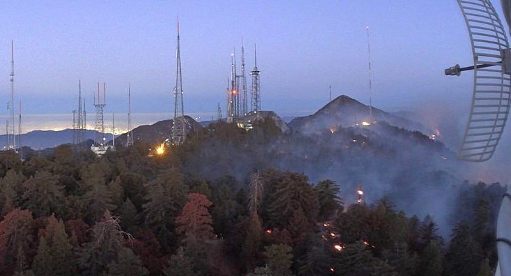
Backfires were successfully set by firefighters, including from the air, to protect the Mt. Wilson Observatory and several broadcast and telecommunications towers from the Bobcat Fire, which has burned 113,307 acres as of Wednesday morning.
Containment of the blaze more than doubled overnight, to 38% this morning from 17% late Tuesday.
The backfires were set from Mt. Wilson down to Redbox Road “as favorable weather conditions allow,” according to the U.S. Forest Service.
Reduced winds, lower temperatures and higher humidity reduced fire activity Tuesday. Warmer and drier conditions were expected Wednesday and Thursday, with southwesterly and up canyon winds, according to the National Weather Service.
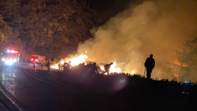
The fire, one of the largest in Los Angeles County history, is burning in the Angeles National Forest and threatening communities in the Antelope Valley and San Gabriel Valley foothills. Flames have destroyed or damaged 29 structures, with authorities fearing the number could rise to 85.
The U.S. Forest Service reported Tuesday afternoon that the defensive firing operation was “going well at Mt. Wilson. They’re using aerial ignitions to increase the buffer between HWY 2 near Barley Flat to Big Tujunga Road.”
But the Los Angeles County Sheriff’s Department cautioned that portions of Pasadena and Altadena were still under evacuation warning as of Tuesday afternoon:
North of Sierra Madre Boulevard, west of Michillinda Avenue, east of Washington Boulevard, north of New York Drive, as well as north of New York Drive and Woodbury Drive, east of Hahamongna Watershed Park.
A smoke advisory was extended through Wednesday warning of unhealthy air in the San Gabriel Mountains, and for sensitive individuals in the San Gabriel Valley, Santa Clarita Valley and Antelope Valley.
“It is difficult to tell where smoke, ash or soot from a fire will go, or how winds will affect the level of these particles in the air, so we ask everyone to remember that smoke and ash can be harmful to health, even for people who are healthy,” said Dr. Muntu Davis, health officer for Los Angeles County.
“If you can see smoke, soot, or ash, or you can smell smoke, pay attention to your immediate environment and take precautions to safeguard your health. These precautions are particularly important for children, older adults, and people with heart or lung diseases.”
A total of 1,556 personnel were assigned to the fire as of Tuesday evening.
A closure order has been issued for national forests in Southern California, including the Angeles National Forest.
Information was not available regarding how many of the burned structures were homes. That assessment was expected to be completed by Wednesday.
The fire has burned more acres than the Woolsey Fire of 2018, which burned 96,271 acres, the Los Angeles County Fire Department said Tuesday. The Station Fire in 2009 burned 160,577 acres.
The fire came down from the Angeles National Forest into Cima Mesa, Juniper Hills, Pearblossom and Devil’s Punchbowl on Friday and damaged some structures, Vince Pena of the Los Angeles County Fire Department said Monday evening.
The Nature Center at the Devil’s Punchbowl Natural Area was burned by the fire, Los Angeles County parks officials said. The area is closed until further notice.
The Bobcat Fire erupted on Sept. 6 near the Cogswell Dam and West Fork Day Use area northeast of Mount Wilson and within the Angeles National Forest. The cause remains under investigation. Full containment is not expected until Oct. 30.
 Get our daily Pasadena newspaper in your email box. Free.
Get all the latest Pasadena news, more than 10 fresh stories daily, 7 days a week at 7 a.m.