


 35 comments
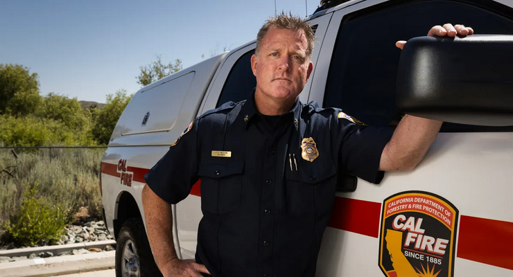
Cal Fire Battalion Chief Jon Heggie wasn’t expecting much to worry about when a late summer fire erupted north of Santa Cruz, home to California’s moist and cool “asbestos forests.” This place doesn’t burn, he thought, with just three notable fires there in 70 years.
Heggie’s job was to predict for the crews where the wildfire might go and when, working through calculations based on topography, weather and fuels — the “immutable” basics. For fire behavior analysts like Heggie, predictable and familiar are manageable, while weird and unexpected are synonyms for danger.
But that 2020 fire was anything but predictable.
Around 3 a.m. on Aug. 16, ominous thunder cells formed over the region. Tens of thousands of lightning strikes rained down, creating a convulsion of fire that became the CZU Lightning Complex.
By noon there were nearly two dozen fires burning, and not nearly enough people to handle them. Flames were roaring throughout the Coast Range in deep-shaded forests and waist-high ferns in sight of the Pacific Ocean. No one had ever seen anything like it. The blaze defied predictions and ran unchecked for a month. The fire spread to San Mateo County, burned through 86,000 acres, destroyed almost 1,500 structures and killed a fleeing resident.
“It was astonishing to see that behavior and consumption of heavy fuels,” Heggie said. “Seeing the devastation was mind-boggling. Things were burning outside the norm. I hadn’t seen anything burn that intensely in my 30 years.”
Almost as troubling was what this fire didn’t do — it didn’t back off at night.
“We would have burning periods increase in the afternoon, and we saw continuous high-intensity burns in the night,” Heggie said. “That’s when we are supposed to make up ground. That didn’t happen.”
“Seeing the devastation was mind-boggling. Things were burning outside the norm. I hadn’t seen anything burn that intensely in my 30 years.”
JON HEGGIE, CAL FIRE BATTALION CHIEF
That 2020 summer of fires, the worst in California history, recalibrated what veteran firefighters understand about fire behavior: Nothing is as it was.
Intensified by climate change, especially warmer nights and longer droughts, California’s fires often morph into megafires, and even gigafires covering more than a million acres. U.S. wildfires have been four times larger and three times more frequent since 2000, according to University of Colorado researchers. And other scientists recently predicted that up to 52% more California forest acreage will burn in summertime over the next two decades because of the changing climate.
As California now heads into its peak time for wildfires, even with last year’s quiet season and the end of its three-year drought, the specter of megafires hasn’t receded. Last winter’s record winter rains, rather than tamping down fire threats, have promoted lush growth, which provides more fuel for summer fires.
Cal Fire officials warn that this year’s conditions are similar to the summer and fall of 2017 — when a rainy winter was followed by one of the state’s most destructive fire seasons, killing 47 people and destroying almost 11,000 structures.
It’s not just the size and power of modern wildfires, but their capricious behavior that has confounded fire veterans — the feints and shifts that bedevil efforts to predict what a fire might do and then devise strategies to stop it. It’s a dangerous calculation: In the literal heat of a fire, choices are consequential. People’s lives and livelihoods are at stake.
Cal Fire crews now often find themselves outflanked. Responding to larger and more erratic and intense fires requires more personnel and equipment. And staging crews and engines where flames are expected to go has been thrown off-kilter.
“We live in this new reality,” Gov. Gavin Newsom said at a recent Cal Fire event, “where we can’t necessarily attach ourselves to some of the more predictive models of the past because of a world that is getting a lot hotter, a lot drier and a lot more uncertain because of climate change.”
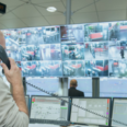
CalFire has responded by tapping into all the new technology — such as drones, military satellites, infrared images and AI-assisted maps — that can be brought to bear during a fire. Commanders now must consider a broader range of possibilities so they can pivot when the firefront shifts in an unexpected way. The agency also has beefed up its ability to fight nighttime fires with a new fleet of Fire Hawk helicopters equipped to fly in darkness.
“We live in this new reality. ..We’re enlisting cutting-edge technology in our efforts to fight wildfires, exploring how innovations like artificial intelligence can help us identify threats quicker and deploy resources smarter.”
GOV. GAVIN NEWSOM
The state has thrown every possible data point at the problem with its year-old Wildfire Threat and Intelligence Integration Center, which pulls information from dozens of federal, state and private sources to create a minute-by-minute picture of conditions conducive to sparking or spreading fires.
“We’re enlisting cutting-edge technology in our efforts to fight wildfires,” Newsom said, “exploring how innovations like artificial intelligence can help us identify threats quicker and deploy resources smarter.”
An unforeseen assault on a coastal town
The 2017 Thomas Fire stands as an example of what happens when a massive fire, ignited after a rainy winter, veers and shifts in unexpected ways.
The blaze in coastal Ventura and Santa Barbara counties struck in December, when fire season normally has quieted down. Fire veterans knew fall and winter fires were tamed by a blanket of moist air and fog.
But that didn’t happen.
“We were on day five or six, and the incident commander comes to me and asks, ‘Are we going to have to evacuate Carpinteria tonight?’,” said Cal Fire Assistant Chief Tim Chavez, who was the fire behavior analyst for the Thomas Fire. “I looked at the maps and we both came to the conclusion that Carpinteria would be fine, don’t worry. Sure enough, that night it burned into Carpinteria and they had to evacuate the town.”
Based on fire and weather data and informed hunches, no one expected the fire to continue advancing overnight. And, as the winds calmed, no one predicted the blaze would move toward the small seaside community of 13,000 south of Santa Barbara. But high temperatures, low humidity and a steep, dry landscape that hadn’t felt flames in more than 30 years drew the Thomas Fire to the coast.
“I looked at the maps and we both came to the conclusion that Carpinteria would be fine, don’t worry. Sure enough, that night it burned into Carpinteria and they had to evacuate the town.”
TIM CHAVEZ, CAL FIRE ASSISTANT CHIEF
The sudden shift put the town in peril. Some 300 residents were evacuated in the middle of the night as the blaze moved into the eastern edge of Carpinteria.
In all, the fire, which was sparked by power lines downed by high winds, burned for nearly 40 days, spread across 281,000 acres, destroyed more than 1,000 homes and other buildings and killed two people, including a firefighter. At the time, it was the largest wildfire in California’s modern history; now, just six years later, it ranks at number eight.
The unforeseen assault on Carpenteria was an I-told-you-so from nature, the sort of humbling slap-down that fire behavior analysts in California are experiencing more and more.
“I’ve learned more from being wrong than from being right,” Chavez said. “You cannot do this job and not be surprised by something you see. Even the small fires will surprise you sometimes.”
Warmer nights, drought, lack of fog alter fire behavior
Scientists say the past 20 years have brought a profound — and perhaps irreversible — shift in the norms of wildfire behavior and intensity. Fires burn along the coast even when there’s no desert winds to drive them, fires refuse to lay down at night and fires pierced the so-called Redwood Curtain, burning 97% of California’s oldest state park, Big Basin Redwoods.
The changes in wildfires are driven by an array of factors: a megadrought from the driest period recorded in the Western U.S. in the past 1,200 years, the loss of fog along the California coast, and stubborn nighttime temperatures that propel flames well into the night.
California’s nighttime fire conditions have worsened
Fires used to “go to bed” and firefighters relied on nighttime conditions to slow the spread of a fire. But some parts of the state have experienced an annual increase in burnable nighttime hours equivalent to an additional month, compared to 40 years ago.
Higher temperatures and longer dry periods are linked to worsening fires in Western forests, with an eightfold increase from 1985 to 2017 in severely burned acreage, according to a 2020 study. “Warmer and drier fire seasons corresponded with higher severity fire,” the researchers wrote, suggesting that “climate change will contribute to increased fire severity in future decades.”
“What we are seeing is a dramatic increase in extreme fire behavior,” Heggie said. “When you have a drought lasting 10 years, devastating the landscape, you have dead fuel loading and available fuel for when these fires start. That’s the catalyst for megafire. That’s been the driving force for change in fire behavior.”
About 33% of coastal summer fog has vanished since the turn of the century, according to researchers at UC Berkeley. That blanket of cool, moist air that kept major fires out of coastal areas can no longer be relied upon to safeguard California’s redwood forests.
Firefighters are losing another ally, too, with the significant increase in overnight temperatures. Nighttime fires were about 28% more intense in 2020 than in 2003. And there are more of them — 11 more “flammable nights” every year than 40 years ago, an increase of more than 40%.
The upshot is that fires are increasingly less likely to “lie down” at night, when fire crews could work to get ahead of the flames. The loss of those hours to perform critical suppression work — and the additional nighttime spread — gives California crews less time to catch up with fast-moving blazes.
Also, fire whirls and so-called firenados are more common as a feature of erratic fire behavior. The twisting vortex of flames, heat and wind can rise in columns hundreds of feet high and are spun by high winds.
Firenados are more than frightening to behold: They spread embers and strew debris for miles and make already dangerous fires all the more risky. One was spotted north of Los Angeles last summer.
Fires are “really changing, and it’s a combination of all kinds of different changes,” said Jennifer Balch, director of the Environmental Data Science Innovation & Inclusion Lab at the University of Colorado Boulder and a longtime fire researcher who tracks trends that drive wildfires.
“We’re losing fog. We’re seeing drier conditions longer and later into the season. And so what that means for California right now is, under these record heat waves, we’re also now butting up against the Santa Ana wind conditions,” she said. “I think we’re loading the dice in a certain direction.”
A fire behaviorist’s day
Among the many specialists at work are fire behavior analysts, who are responsible for predicting a fire’s daily movements for the incident commander. As a fire rages, Cal Fire analysts get their information in an avalanche of highly technical data, including wind force and direction, temperature and humidity, the shape and height of slopes, the area’s burn history, which fuels are on the ground and, in some cases, how likely they are to burn.
Gleaned from satellites, drones, planes, remote sensors and computer mapping, the information is spat out in real time and triaged by the fire behavior analyst, who often uses a computer program to prepare models to predict what the fire is likely to do.
That information is synthesized and relayed — quickly — to fire bosses. Laptops and hand-held computers are ubiquitous on modern firelines, replacing the time-honored practice of spreading a dog-eared map on the hood of a truck.
“On a typical day I would get up at 4:30 or 5,” said Chavez, who has served as a fire behavior analyst for much of his career. “We get an infrared fire map from overnight aircraft, and that tells us where the fire is active. Other planes fly in a grid pattern and we look at those still images. I might look at computer models, fire spread models, and the weather forecast. There’s other data that tells you what fuels are in the area. You plug all that in to see where the fire will be 24 hours from now.”
At the fire camp’s 8 a.m. briefing, “you get two minutes to tell people what to watch out for,” he said. Throughout the day, Chavez says he monitors available data and hitches a helicopter ride to view the fire from the air. At another meeting at 5 p.m., he and other officers prepare the next day’s incident action plan. Then he’s back to collating more weather and fire data. The aim is to get to bed before midnight.
The importance of the fire behavior analyst’s job is reflected by the sophistication of the tools available: real-time NOAA satellite data, weather information from military flights, radar, computer-generated maps showing a 100-year history of previous burns in the area as well as the current fuel load and its combustibility, airplane and drone surveillance and AI-enabled models of future fire movements. Aircraft flying over fires provide more detail, faster, about what’s inside fire plumes, critical information to fire bosses.
In California, the National Guard is entering the fourth year of an agreement to share non-classified information pulled from military satellites that scan for heat signatures from the boost phase of ballistic missiles. When those heat images are associated with wildfires, the agency’s FireGuard system can transmit detailed information to Cal Fire every 15 minutes.
Meteorologist Craig Clements, director of the Fire Weather Research Laboratory at San Jose State University, has chased fires for a decade.
“We can pull up on a fire, and the radar starts spinning and you’re peering into a plume within four minutes,” Clements said. “It gives us information about the particles inside, the structure of it.”
Fire behavior decisions are not totally reliant on outside data inputs. Seasoned fire commanders remain firmly committed to a reliable indicator: the hair on the back of their necks.
Fireline experience and hard-earned knowledge still counts when formulating tactics. But it’s a measure of how norms have shifted that even that institutional knowledge can fail.
Future of firefighting: AI crunches billions of data points
Perhaps the biggest leap is applying artificial intelligence to understand fire behavior. Neil Sahota, an AI advisor to the United Nations and a lecturer at UC Irvine, is developing systems to train a computer to review reams of data and come to a predictive conclusion.
The idea is not to replace fire behavior analysts and jettison their decades of fireline experience, Sahota said, but to augment their work — and, mostly, to move much faster.
“We can crunch billions of different data points in near real time, in seconds,” he said. “The challenge is, what’s the right data? We may think there are seven variables that go into a wildfire, for example. AI may come back saying there are thousands.”
In order for their information to be useful, computers have to be taught: What’s the difference between a Boy Scout campfire and a wildfire? How to distinguish between an arsonist starting a fire and a firefighter setting a backfire with a drip torch?
“We can crunch billions of different data points in near real time, in seconds. The challenge is, what’s the right data?”
NEIL SAHOTA, AI ADVISOR TO THE UNITED NATIONS AND UC IRVINE LECTURER
Despite the dizzying speed at which devices have been employed on the modern fireline, most fire behavior computer models are still based on algorithms devised by Mark Finney, a revered figure in the field of fire science.
Working from the Missoula Fire Sciences Laboratory in Montana, Finney has studied fire behavior through observation and, especially, by starting all manner of fires in combustion chambers and in the field. In another lab in Missoula, scientists bake all types of wood in special ovens to determine how fuels burn at different moisture levels.
Still, Finney is unimpressed by much of the sophisticated technology brought to bear on wildfires as they burn. He said it provides only an illusion of control.
“Once you are in a position to have to fight these extreme fires, you’ve already lost,” he said. “Don’t let anybody kid you, we do not suppress these fires, we don’t control them. We wait for the weather.”
The Missoula research group developed the National Fire Danger Rating System in 1972, which is still in place today. Among the fire behavior tools Finney designed is the FARSITE system, a simulation of fire growth invaluable to frontline fire bosses.
“Don’t let anybody kid you, we do not suppress these fires, we don’t control them. We wait for the weather.”
MARK FINNEY, MISSOULA FIRE SCIENCES LABORATORY
Finney and colleagues are working on a next-generation version of the behavior prediction system, which is now undergoing real-world tests.
“This equation has an awful lot of assumptions in it,” he said. “We’re getting there. Nature is a lot more complicated. There are still a number of mysteries on fire behavior. We don’t have a road map to follow that tells us that this is good enough.”
By far the best use of the predictive tools that he and others have developed is to learn how to avoid firestarts, he said, by thinning and clearing forests to reduce threat.
“I would love to tell you that the key to solving these problems is more research. But if we just stopped doing research and just use what we know, we’d be a lot better off.”
Still, research about fire behavior races on, driven by the belief that you can’t fight an enemy you don’t understand.
Mike Koontz is on the frontlines of that battle, tucked into a semicircle of supercomputers. Koontz leads a team of researchers in Boulder, Colo., studying a new, volatile and compelling topic: California megafires.
“We began to see a clear uptick in extreme fire behavior in California since the 2000s,” said Koontz, a postdoctoral researcher with the Earth Lab at University of Colorado Boulder. “We keyed in on fires that moved quickly and blew up over a short period of time.” California is a trove of extreme fires, he said.
Koontz is using supercomputers to scrape databases, maps and satellite images and apply the data to an analytical framework of his devising. The team tracks significant fires that grow unexpectedly, and layers in weather conditions, topography, fire spread rates and other factors.
What comes out is a rough sketch of the elements driving California’s fires to grow so large. The next hurdle is to get the information quickly into the hands of fire commanders, Koontz said.
The goal: if not a new bible for fighting fires, at least an updated playbook.
CalMatters.org is a nonprofit, nonpartisan media venture explaining California policies and politics.
 Get our daily Pasadena newspaper in your email box. Free.
Get all the latest Pasadena news, more than 10 fresh stories daily, 7 days a week at 7 a.m.