Latest Guides

Science and Technology

JPL Scientists Help Map Beirut Blast Damage

Scientists are using satellite data to map ground surface changes in the aftermath of the recent explosion.

Published on Friday, August 7, 2020 | 3:47 pm
 
NASA’s ARIA team, in collaboration with the Earth Observatory of Singapore, used satellite data to map the extent of likely damage following a massive explosion in Beirut. Dark red pixels represent the most severe damage. Areas in orange are moderately damaged, and areas in yellow are likely to have sustained somewhat less damage. Each colored pixel represents an area of 30 meters (33 yards). The map contains modified Copernicus Sentinel data processed by ESA (European Space Agency) and analyzed by ARIA team scientists at NASA’s Jet Propulsion Laboratory, Caltech, and Earth Observatory of Singapore. Based in Pasadena, California, Caltech manages JPL for NASA.

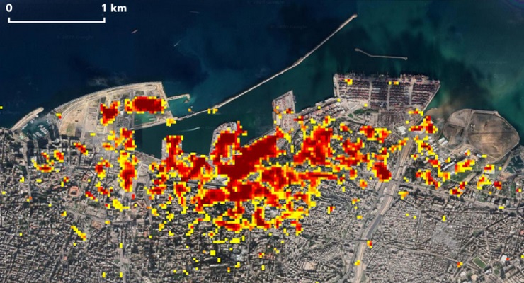
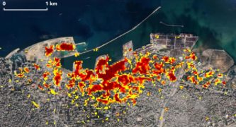
Jet Propulsion Laboratory’s Advanced Rapid Imaging and Analysis (ARIA) team in Pasadena, in collaboration with the Earth Observatory of Singapore, used satellite-derived synthetic aperture radar data to map the likely extent of damage from a massive Aug. 4 explosion in Beirut.

Synthetic aperture radar data from space shows ground surface changes from before and after a major event like an earthquake. In this case, it is being used to show the devastating result of an explosion.

NASA’s ARIA team, in collaboration with the Earth Observatory of Singapore, used satellite data to map the extent of likely damage following a massive explosion in Beirut. Dark red pixels represent the most severe damage. Areas in orange are moderately damaged, and areas in yellow are likely to have sustained somewhat less damage. Each colored pixel represents an area of 30 meters (33 yards). The map contains modified Copernicus Sentinel data processed by ESA (European Space Agency) and analyzed by ARIA team scientists at NASA’s Jet Propulsion Laboratory, Caltech, and Earth Observatory of Singapore. Based in Pasadena, California, Caltech manages JPL for NASA.

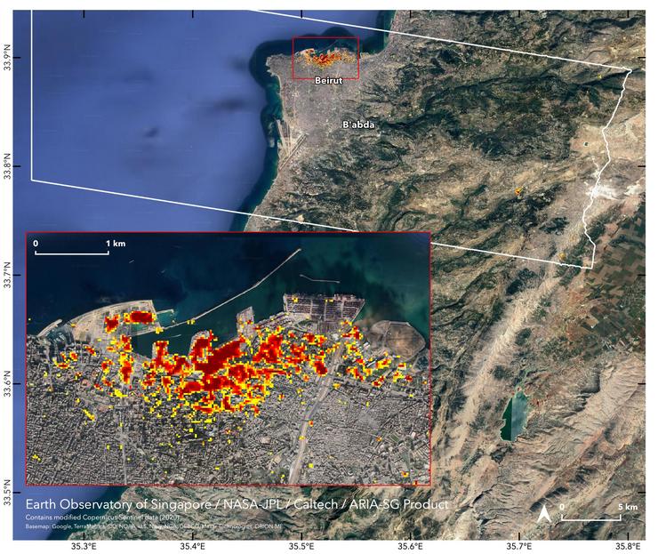
On the map, dark red pixels — like those present at and around the Port of Beirut — represent the most severe damage. Areas in orange are moderately damaged and areas in yellow are likely to have sustained somewhat less damage. Each colored pixel represents an area of 30 meters (33 yards).

Maps like this one can help identify badly damaged areas where people may need assistance.

The explosion occurred near the city’s port. It claimed more than 150 lives and is estimated to have caused billions of dollars’ worth of damage.

The map contains modified Copernicus Sentinel data processed by ESA (European Space Agency) and analyzed by ARIA team scientists at NASA JPL, Caltech, and Earth Observatory of Singapore.

ARIA is a collaboration between JPL and Caltech to exploit radar and optical remote sensing, GPS, and seismic observations for hazard science and response.

More information on ARIA can be found here: https://aria.jpl.nasa.gov/

Get our daily Pasadena newspaper in your email box. Free.

Get all the latest Pasadena news, more than 10 fresh stories daily, 7 days a week at 7 a.m.

Make a comment

Your email address will not be published. Required fields are marked *


buy ivermectin online
buy modafinil online
buy clomid online
buy ivermectin online