


 1 comment

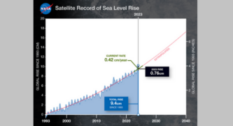
This graph shows global mean sea level (in blue) since 1993 as measured by a series of five satellites. The solid red line indicates the trajectory of this increase, which more than doubled over the past three decades. The dotted red line projects future sea level rise. Credit: NASA-JPL/Caltech
Global average sea level rose by about 0.3 inches (0.76 centimeters) from 2022 to 2023, a relatively large jump due mostly to a warming climate and the development of a strong El Niño. The total rise is equivalent to draining a quarter of Lake Superior into the ocean over the course of a year, according to scientists.
Jet Propulsion Laboratory in Pasadena played a large role in this National Aeronautics and Space Administration-led analysis based on a sea level dataset featuring more than 30 years of satellite observations.
The data shows that global average sea level has risen a total of about 4 inches (9.4 centimeters) since 1993. The rate of this increase has also accelerated, more than doubling from 0.07 inches (0.18 centimeters) per year in 1993 to the current rate of 0.17 inches (0.42 centimeters) per year.
Global sea level saw a significant jump from 2022 to 2023 due mainly to a switch between La Niña and El Niño conditions. A mild La Niña from 2021 to 2022 resulted in a lower-than-expected rise in sea level that year. A strong El Niño developed in 2023, helping to boost the average amount of rise in sea surface height.
Cooler-than-normal ocean temperatures in the equatorial Pacific Ocean characterize La Niña. El Niño involves warmer-than-average ocean temperatures in the equatorial Pacific. Both periodic climate phenomena affect patterns of rainfall and snowfall as well as sea levels around the world.
“During La Niña, rain that normally falls in the ocean falls on the land instead, temporarily taking water out of the ocean and lowering sea levels,” said Josh Willis, a sea level researcher at the National Aeronautics and Space Administration’s Jet Propulsion Laboratory in Southern California. “In El Niño years, a lot of the rain that normally falls on land ends up in the ocean, which raises sea levels temporarily.”
The Jet Propulsion Laboratory’s involvement includes the development and management of satellite missions that provide critical data for sea level measurements. The TOPEX/Poseidon mission, launched in 1992, marked the beginning of over 30 years of satellite observations contributing to the sea level dataset. The Sentinel-6 Michael Freilich mission, launched in November 2020, is the latest satellite to continue this legacy, providing high-precision ocean surface height measurements.
“Long-term datasets like this 30-year satellite record allow us to differentiate between short-term effects on sea level, like El Niño, and trends that let us know where sea level is heading,” said Ben Hamlington, lead for the National Aeronautics and Space Administration’s sea level change team at the Jet Propulsion Laboratory.
The Jet Propulsion Laboratory team also cross-checks satellite data with other sources, such as tide gauges and measurements of atmospheric water vapor and Earth’s gravity field, to ensure the accuracy of sea level measurements. This comprehensive approach allows for the recalibration of the long-term dataset, leading to updates in sea levels for previous years, such as the noted increase of 0.08 inches (0.21 centimeters) from 2021 to 2022.
 Get our daily Pasadena newspaper in your email box. Free.
Get all the latest Pasadena news, more than 10 fresh stories daily, 7 days a week at 7 a.m.